


Voting District 1475160000001, St. Clair County, Michigan
About
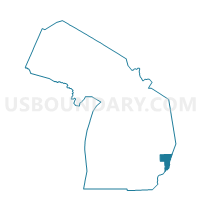
Outline

Summary
| Unique Area Identifier | 599444 |
| Name | Voting District 1475160000001 |
| County | St. Clair County |
| State | Michigan |
| Area (square miles) | 0.39 |
| Land Area (square miles) | 0.39 |
| Water Area (square miles) | 0.00 |
| % of Land Area | 100.00 |
| % of Water Area | 0.00 |
| Latitude of the Internal Point | 42.72055340 |
| Longtitude of the Internal Point | -82.49329120 |
Maps


Graphs
Select a template below for downloading or customizing gragh for Voting District 1475160000001, St. Clair County, Michigan


Neighbors
Neighoring Voting District (by Name) Neighboring Voting District on the Map
- Voting District 1472382000001, St. Clair County, MI
- Voting District 1472382000002, St. Clair County, MI
- Voting District 1475160000002, St. Clair County, MI
- Voting Districts not defined, St. Clair County, MI
Top 10 Neighboring County Subdivision (by Population) Neighboring County Subdivision on the Map
- Marine City city, St. Clair County, MI (4,248)
- East China township, St. Clair County, MI (3,788)
- Cottrellville township, St. Clair County, MI (3,559)